Victoria bushfire destruction revealed by aerial footage
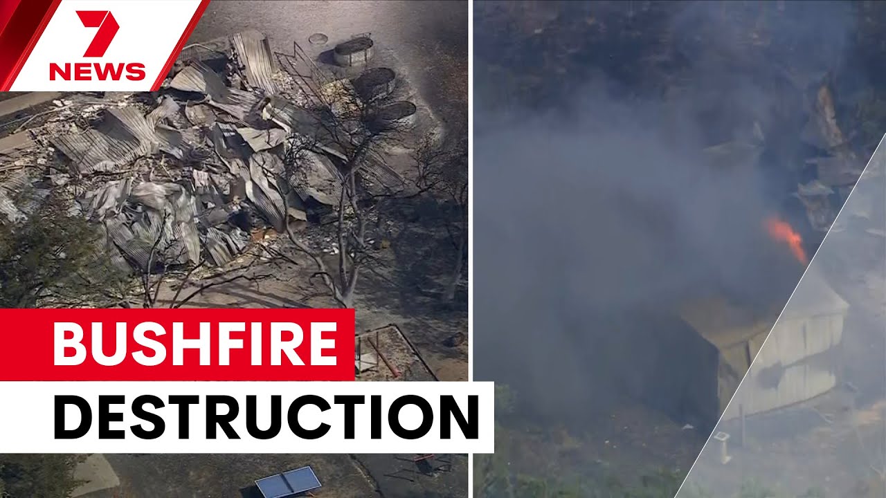
Table of Contents
- State-wide fire ban as helicopter images show widespread damage
- What the aerial images show
- Where and when this is happening
- Who is involved and how emergency response is working
- Immediate safety steps for residents
- Why aerial perspective matters
- Impact on communities and recovery outlook
- Key takeaways
- Frequently asked questions
State-wide fire ban as helicopter images show widespread damage
VICTORIA, AUSTRALIA — Victoria bushfire destruction is laid bare in dramatic aerial footage captured by the 7NEWS helicopter as a catastrophic fire day unfolds. A total fire ban has been declared state-wide while multiple out-of-control blazes burn through bushland and threaten communities, with some properties feared lost.
The footage offers a broad, unsettling view of charred landscapes, advancing fire fronts and emergency crews working under difficult conditions. Local authorities have issued urgent warnings and evacuation advice for affected regions; residents are being urged to follow official channels and not to return to damaged areas until declared safe.
What the aerial images show
From the air, the scale of damage is immediate: kilometres of blackened scrub, smoke plumes rising against the horizon and isolated homes surrounded by scorched vegetation. The helicopter captured both the active flames and the aftermath — properties with severe roof and external damage are visible in several locations.
These shots make clear the speed at which fire can change direction and intensity, forcing rapid decisions for residents and emergency services. Emergency controllers have emphasised that conditions can shift quickly and that footage from above helps incident managers prioritise resources.
Where and when this is happening
Authorities have reported multiple firegrounds across Victoria during the declared catastrophic fire day. The statewide total fire ban signals extreme risk driven by hot, dry conditions and forecast winds that elevate the chance of spot fires and rapid fire spread.
Evacuation centres and local briefings are being organised in towns closest to active fire fronts. Transport and utilities may be disrupted; residents should expect ongoing emergency activity across affected corridors.
Who is involved and how emergency response is working
Firefighters, incident management teams, aerial assets and local councils are coordinating on-ground and aerial response. The helicopter footage assists in identifying accessible fire edges, spotting embers and locating structures at immediate risk, guiding where ground crews and water-bombing aircraft should concentrate efforts.
Community volunteers and relief services are also mobilising to support displaced residents. Emergency services continue to ask the public to keep clear of affected routes to allow safe access for response vehicles.
Immediate safety steps for residents
- Monitor official sources such as VicEmergency, local council alerts and emergency services for verified instructions.
- If you are in an alert or advice area, prepare your household plan and emergency kit now; if an evacuation order is given, leave immediately.
- Protect yourself from smoke by staying indoors with windows and doors closed and following health advice, especially for people with respiratory conditions.
- Do not return to properties until authorities confirm it is safe. Downed powerlines, hot spots and structural damage can pose ongoing risks.
Why aerial perspective matters
Helicopter and fixed-wing imagery provide a rapid, wide-area view that ground crews cannot achieve alone. Aerial reconnaissance helps to:
- Locate active fire fronts and ember attacks.
- Assess damage quickly to prioritise lifesaving tasks.
- Inform public briefings so communities understand risks and the scale of impact.
While confronting, these images are an essential tool for targeting resources and planning recovery work once the immediate threat passes.
Impact on communities and recovery outlook
Communities affected by the fires face immediate loss of property, local infrastructure damage and emotional trauma. Recovery will involve damage assessments, insurance processes and long-term rebuilding supported by local and state agencies.
Community support services and relief funds are typically activated after major incidents; residents should contact their local council or emergency relief centres for information on assistance and registration.
Key takeaways
- Victoria is experiencing a catastrophic fire day with a statewide total fire ban in force.
- 7NEWS helicopter footage shows extensive bushfire destruction and properties feared lost.
- Residents must follow official evacuation orders and safety advice from emergency services.
- Aerial imagery plays a crucial role in directing the firefighting response and shaping recovery priorities.
Frequently asked questions
How widespread is the destruction shown in the aerial footage?
The helicopter images reveal large swathes of scorched bushland and multiple sites where properties appear damaged or destroyed. The footage covers several active firegrounds across Victoria and indicates a broad geographic impact rather than a single isolated blaze.
Are properties definitely lost?
Emergency footage suggests several properties have been badly damaged and are feared lost. Final confirmation requires on-ground assessments once areas are safe to access; authorities will provide verified damage reports in the days following the fires.
What warnings should people follow?
Follow VicEmergency, local council alerts and official emergency service channels. Heed evacuation orders immediately and do not return to affected areas until declared safe by authorities.
How can residents prepare if they are in threatened areas?
Prepare an emergency plan and kit, follow official advice, pack essential documents and medications, and plan multiple escape routes. If told to leave, do so without delay. Keep vehicles fuelled and phone batteries charged.
How can people help those affected?
Support can be offered through verified relief organisations, local community appeals and by donating to official funds. Avoid sharing unverified images or rumours on social media; rely on and amplify official updates to help keep communities informed.
The information in this article has been adapted from mainstream news sources and video reports published on official channels. Watch the full video here Victoria's bushfire destruction revealed from 7News helicopter | 7NEWS


