Table of Contents
Third day of storms, hail and strong winds sweep south-east Queensland
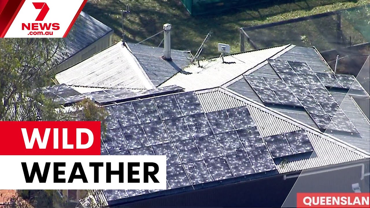
SOUTH-EAST QUEENSLAND, AUSTRALIA — Wild weather across Queensland is returning for a third consecutive day as a cooler change moves through the region. Hailstones described as the size of tennis balls and wind gusts exceeding 100 kilometres per hour battered large parts of the state over the weekend, and forecasters warn severe thunderstorms may linger along the east coast from Brisbane to central Queensland.
The Bureau and local meteorologists say cooler conditions and rain are expected to follow the storm activity. Residents and drivers are being urged to take care — especially during the evening and overnight periods when showers and storms are most likely to develop.
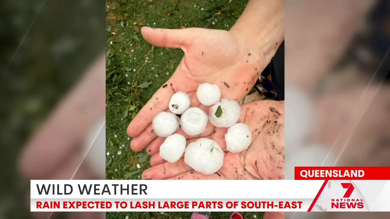
Over the weekend, authorities reported hail as large as tennis balls and destructive wind gusts topping 100 km/h across several communities. Emergency services reminded people to avoid flooded roads and to secure loose outdoor items as the gusty conditions can cause debris and further damage.

Severe thunderstorm risk remains highest on the east coast, from Brisbane north through to central Queensland. This means possible heavy downpours, damaging winds and isolated large hail for some areas, particularly where storms redevelop during the afternoon or evening.
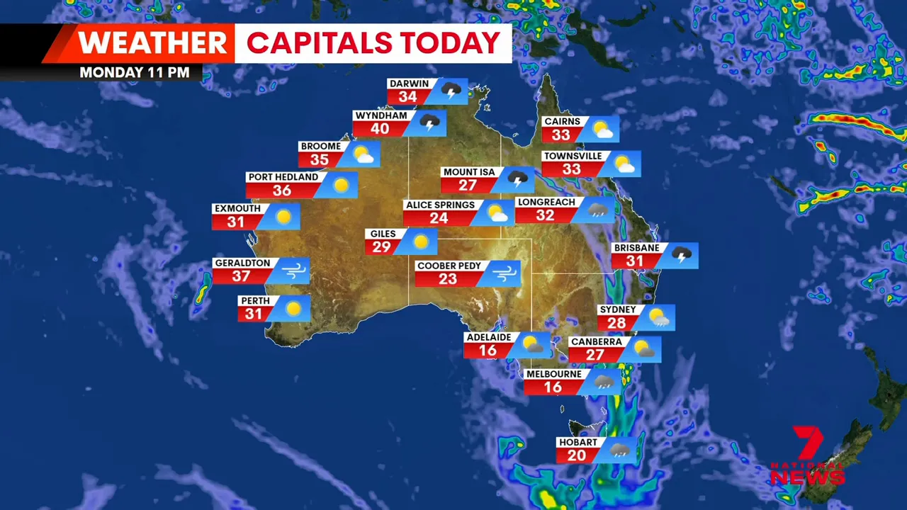
Today’s forecast across capital cities
- Brisbane: Late showers developing; daytime top around 31°C.
- Sydney: Possible evening shower; top near 28°C.
- Canberra: Chance of a thunderstorm; top about 27°C.
- Melbourne: Heavy rain on the way with a cool top near 16°C.
- Adelaide: Wet conditions likely with showers and a chance of thunderstorms; cooler top around 20°C.
- Perth: Sunny spells expected with a warm top near 31°C.
- Darwin: Possible showers with an afternoon storm and a top around 34°C.


Forecasters say conditions will vary across the country, with the most immediate impacts centred on south-east Queensland. Those in the path of storms should monitor warnings and the latest forecasts for changes to timing or severity.
Practical advice for residents
Secure outdoor furniture and garden items, and avoid driving through flooded roads. If you must travel, plan routes carefully and allow extra time. Heavy hail can damage vehicles and property, so move cars under cover where possible and keep pets indoors.
Emergency services recommend checking local council pages and the Bureau of Meteorology for real‑time warnings and updates. If you see dangerous conditions, report them to local authorities.
Will the severe storms continue along the east coast?
Severe thunderstorms may linger from Brisbane to central Queensland into the coming day, particularly during the afternoon and evening. Keep an eye on warnings from the Bureau of Meteorology as storm development can be localised and change quickly.
How large was the hail reported over the weekend?
Hailstones up to the size of tennis balls were reported in parts of the state, causing damage to property and vehicles in affected areas.
Are wind gusts expected to remain strong?
Wind gusts exceeded 100 kilometres per hour over the weekend in some places. Gusty conditions may continue around thunderstorms and in areas affected by the cooler change, so secure loose items and take caution when driving high-profile vehicles.
Which cities will see heavy rain today?
Melbourne is forecast to see heavy rain with cooler conditions, while Adelaide, Brisbane and parts of the east coast may also experience showers and storms. Always check the latest local forecasts for timing and intensity.
What should I do if my area receives a severe thunderstorm warning?
Follow official guidance: move indoors, stay away from windows, secure loose outdoor items, avoid driving through floodwater, and monitor emergency services and the Bureau of Meteorology for updates.
Key takeaways
- South‑east Queensland faces a third consecutive day of stormy weather with hail and damaging winds.
- Severe thunderstorms may linger from Brisbane to central Queensland, with localised heavy rain and gusts.
- Across the country, conditions will range from heavy rain in Melbourne to sunny weather in Perth and storm chances in Darwin.
- Residents should monitor official warnings and secure property ahead of storms.
The information in this article has been adapted from mainstream news sources and video reports published on official channels. Watch the full video here Wild weather continues across Queensland | 7NEWS


